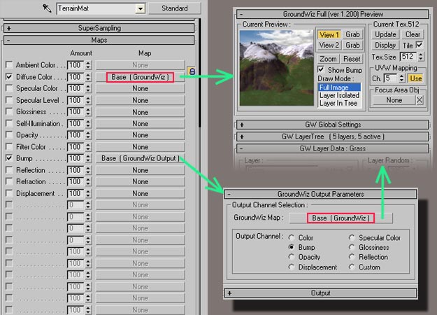
Picture1: using a single instance of GroundWiz as Diffuse map and Bump map.
Use of GroundWiz Output map is recommended in cases where GroundWiz layer data other than color is required.
The main building blocks of GroundWiz are layers. Each layer is in essence a map with its own color, bump, displacement, specularity, distribution parameters, etc. To simulate nature, layers have controlled random features that allow us to hide repetitions and create 'natural' ever changing look. A base for these random features is 3D noise function. In GroundWiz, this function (formula) is used to control or modify almost every parameter.
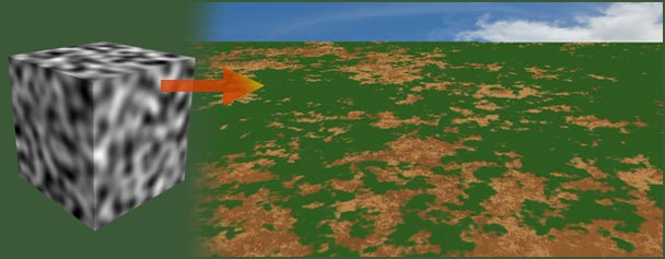
Picture2: in this example, 3D noise function controls random placement of green layer.
Layer parameters are divided into the following groups:
All layers are placed in a tree structure where each layer is affected by its own parameters and also those of its parent. This tree structure allows complex composition of ground to be simulated. You can use as many layers as necessary, layers for rocks, grass, dirt, gravel, snow, and so on. These layers are put on top of each other just like in real life.
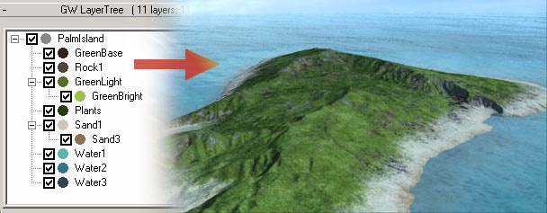
Picture3: 11 layers are used to create the island terrain.
Material that uses GroundWiz map is not limited to be applied to one object; instead, it can be applied to as many objects as necessary. If GroundWiz is used in world space mode, the transitions between different objects are seamless. Any type of geometric object can be used (e.g. editable meshes, patches, nurbs, primitives and so on). Also, shape and object structure are not limited to the typical terrain object but can be hanging cliffs, caves, etc.
An importer that creates optimized terrain mesh is distributed with GroundWiz. It will import 3Dem *.bin files, binary data (raw float, integer, short, byte data) and also Terragen terrain *.ter files. For details, refer to Importing Terrain Files.
Finally if you have terrain surfaces already created for program Terragen, GroundWiz also allows you to import them as layers. For details, refer to Importing Terragen World / Surface Files.